


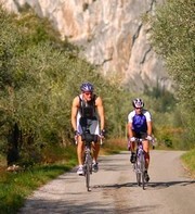
.jpg)
n°1 > Marocche
.jpg)
Lenght: 27 Km
Difference in height: 185 m
Hours: 3.00 h
Difficult: Middle
The path to the nothern limits of the Valle del Sarca is long but not difficult. From the bridge in Arco the path follows the right side of the river and the high cliff of the castle. The first stretch of the path, which is surfaced, passed through Prabi where it is worthwhile paying a visit to the old church of Saint Apollonaire and Saint Pauls Hermitage. After passing by the Roman bridge on the right at Ceniga, the path becomes rougher, but never demanding, before finally arriving at the Ciclamino motor-cross circuit at Pietramurata. Worthy of note are the smooth rock face of Monte Brento and the Parete Zebrata (zebra rock face), both highly popular as rock faces for traditional climbing practice.
More...
n°2 > Monte Velo
.jpg)
Lenght: 30 Km
Difference in height: 1020 m
Hours: 4.00 h
Difficulty: Difficult
From the car park near the bridge over the River Sarca at Arco, after passing the foot-bridge over the river, carry on towards the Capuchin Monks Monastery. At the village of Massone, go under the little ancient portico as far as a fresh-water fountain. Following the sign-posts for Troiana a surfaced road climbs up as far as Pianaura, famous for its magnificent chestnut trees and rock engravings. At the beginning of the hill there is a rock-climbing face situated just below the old oolite quarriews (a calcareous stone used for ornamental friezes and building).
More...
n°3 > Laghel
.jpg)
Lenght: 30 Km
Difference in height: 310 m
Hours: 3.00 h
Difficulty: Middle
From Via Pernone in Riva del Garda, follow the road as far as the Varone water-fall where an easy route on the right leads gradually up through splendid olive groves dotted around the valley of Arco and on through the ancient villages of Ceole, Varignano and Vigne. Here it joins up with a difficult though brief climb up to the little church of Santa Maria di Laghel. From here the path leads left through woods and scattered boulders as far as the descent down a technical path, at times almost non-existent, which comes out near the Roman bridge at Ceniga.
More...
n°4> Doss Casìna
.jpg)
Lenght: 25 Km
Difference in height: 1062 m
Hours: 3.30 h
Difficult: Middle
From the town square in Torbole, take the road uphill towards the Busatte activity park. Follow the cobbled path in the Santa Lucia valley as far as the junction with the Mount Baldo road which climbs up on the right with steep hairpin bends leadings up to Malga Zures. Here the path follows the visible tracks of the first world war defence lines and levels out for a while before the steep climb up to Malga Casina.
More...
n°5 > Malga Campo
.jpg)
Lenght: 38 Km
Difference in height: 1438 m
Hours: 5.30 h
Difficult: Difficult
An initially effortless path begins at the bridge in Arco, leading along the new cycling path on the left side of the River Sarca as far as the village of Ceniga. Turn right and cross the S.S. 45bis state road which leads to a flat country road which, after approximately 3 km, comes out at Dro on the provincial road leading to Drena, passing through Maso Giare and splendid orchard. After a series of bends affording magnificent views its well worthwhile stopping for a visit to the splendid Drena Castle.
More...
n°6 > Lago di Tenno
.jpg)
Lenght: 25 Km
Difference in height: 555 m
Hours: 2.00 h
Difficult: Middle
The path begins in Riva del Garda, taking the Via Pernone and turning left at the bottom on the state road for Tenno before coming to the Varone waterfalls. About 200 metres after the spectacular ravine, just near the sign-post for Gavazzo, a surfaced road to the left climbs up to the village of Cologna before joining the S.S. 421; after following the state road for 600 metres turn off at the first anti-clockwise bend for the Volta di Nò.
More...
n°7 > Malga Grassi
.jpg)
Lenght: 29 Km
Difference in height: 983 m
Hours: 3.00 h
Difficult: Middle
The path begins in Via Ardano in Riva del Garda, goes beyond San Giacomo and joins the S.P. 37 provincial road leading to Deva and Pranzo. After the village of Pranzo, at the second hairpin bend, turn left for Campi through a splendid chestnut grove. After passing through the village, turn right towards Malga Grassi. Just above, there is an easy dirt track which leads to the archaeological area of San Martino with its Roman ruins.
More...
n°8> San Giovanni al monte
.jpg)
Lenght: 29 Km
Difference in height: 1170 m
Hours: 3.30 h
Difficult: Difficult
The path begins with a steep climb from above the town of Varignano to the delightful valley of Padaro, where a brief stretch of flat road is followed by another slight, but constant climb. Carry on as far as Mandrea where on the right there is a splendid view of the Valle dei Laghi. After the first country dwellings of San Giovanni, go past the pretty little church until you see the refuge-restaurant below. Going up towards Prai da Gom-Gorghi, the road becomes a dirt track and after turning left at Marcarìe, passes below the slopes of Monte Biaìla, which is flanked by vast forests and a green valley.
More...
n°9 > Tour of the Busa
Lenght: 18 Km
Difference in height: 150 m
Hours: 1.40 h
Difficult: Easy
From the car park near the bridge over the River Sarca turn right through the old town centre of Arco. The path then goes towards the village of San Giorgio, almost as far as Rione Degasperi, along the network of country roads through the sunny vineyards and orchards to the right of the S.S. 45bis; from here, turn left towards the hamlet of S.Alessandro and the broad, comfortable road, protected by a cycling path, which leads straight to Porto San Nicolò at Riva del Garda, just a few metres from the lake.
More...
Cookies help us to deliver our services. By using these services, you agree to the use of cookies on the Website. More info


© 2015 VisitGarda All Rights Reserved c.f. e p.i. 02081030229
 Powered by iSite
iVision Group